Fort Orange Light, Sekondi -Photo
taken January 2008
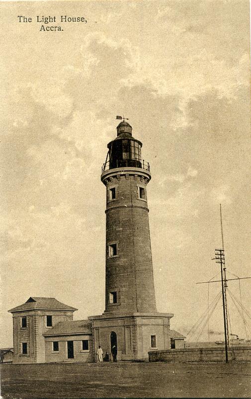
Accra (Jamestown) Light -Photo
taken March 2012
Takoradi Light -Photo taken 1990
Cape Three Points Light -Photo
taken January 2006
Title: Lighthouses of Ghana
Ghana is a former British colony located on the south side of West Africa between Côte d'Ivoire and Togo. In 1957 it became the first country in sub-Saharan Africa to be granted its independence. Its coastline, formerly called the Gold Coast, extends for about 540 km (335 mi) on the Gulf of Guinea. The principal ports, Takoradi and Tema, are close to the cities of Sekondi and Accra, respectively.
Aids to navigation in Ghana are maintained by the Ghana Ports and Harbours Authority (GPHA). Compared to other West African nations, Ghana has done a good job of maintaining its historic lighthouses.
ARLHS numbers are from the ARLHS World List of Lights. Admiralty numbers are from volume D of the Admiralty List of Lights & Fog Signals. U.S. NGA List numbers are from Publication 113. |
Volta Region Lighthouse
* Cape St. Paul (Woe)
1901. Active; focal plane 23 m (75 ft); one long (1.7 s) flash every 15 s. 25 m (83 ft) pyramidal cast or wrought iron skeletal tower, upper third enclosed, with lantern and gallery. Lighthouse painted with red and white horizontal bands. The photographer of a closeup photo says the lighthouse is "nonworking," but this seems unlikely since the photo shows it with fresh paint. Another photo and a distant photo are also available, but clouds block Google's satellite view. A remarkable lighthouse, with a design very rare for Africa. Located at Woe, about 10 km (6 mi) south of Keta in easternmost Ghana. Site open, tower status unknown. ARLHS GHA-004; Admiralty D3168; NGA 24924.
Greater Accra Region Lighthouses
- * Chemu (Breaker) Point (Tema)
- Date unknown (modern). Active; focal plane 47 m (154 ft); white flash every 7.5 s. Approx. 40 m (131 ft) tapered concrete (?) tower with lantern and gallery. Lighthouse painted with black and white vertical stripes; lantern is white. Trabas has Capt. Peter's distant photo, Doug Murray has a 2007 view from the sea, and Google has a satellite view. Located on a low hill about 1.5 km (1 mi) northeast of the harbor facilities in Tema, about 30 km (19 mi) east northeast of Accra. Site probably open, tower probably closed. ARLHS GHA-003; Admiralty D3167; NGA 24896.
-
- Tema Lee Breakwater (2)
- Date unknown. Active; focal plane about 17 m (56 ft); green light, 5 s on, 5 s off. 15 m (49 ft) round cylindrical tower, painted green. Trabas has Capt. Peter's photo, Dan Spencer has a photo, and Google has a satellite view. The former light, a post light less than half as tall, stands next to the new tower. Located at the end of the lee (north) breakwater at Tema. Site status unknown. Admiralty D3167.4; NGA 24908.
-
- Tema Main Breakwater (2)
- Date unknown. Active; focal plane about 17 m (56 ft); three red flashes, two short and one long, every 10 s. 15 m (49 ft) round cylindrical tower, painted red. Trabas has Capt. Peter's photo, Dan Spencer has a photo, and Google has a satellite view. The former light, a post light less than half as tall, stands next to the new tower. Located at the end of the main (south) breakwater at Tema. Site status unknown. Admiralty D3167.2; NGA 24904.
-
- *** Accra (Jamestown) (2)
- Date unknown (1920s or early 1930s; station established 1871). Active; focal plane 34 m (112 ft); four white flashes, separated by 3 s, every 25 s. 28 m (92 ft) stone tower with lantern and gallery, attached to a 1- and 2-story keeper's house. Lghthouse and keeper's house painted with red and white horizontal bands. Carsten ten Brink's photo is at right, Huelse has a historic postcard view, and Google has a satellite view. The lighthouse was formerly painted white with blue trim, as seen in Kara van Malssen's 2009 photo and a 2008 photo. Accra, the capital city of Ghana, was originally two settlements, one British and one Dutch, with Jamestown being the British outpost. The lighthouse is in a very poor district of the city (this photo shows a bit of the surroundings), but guided tours can be arranged locally. The tower itself appears to be in fairly good condition, as shown by an interior photo. In 2011 the lighthouse was refurbished and repainted, and a TRB-220 rotating solar-powered light was installed. Nearby is Fort James, the British outpost dating from the late 1700s; a photo by Brian McMorrow shows the lighthouse rising behind the fort. Located near a point of land on the southwest side of Accra. Site open with due caution, tower open for climbing. ARLHS GHA-001; Admiralty D3162; NGA 24884.
|
Central Region Lighthouse
- *** Fort William (Cape Coast Castle)
- 1835. Inactive since the 1970s as a lighthouse, although flashing red lights on the radio masts are listed as a minor navigational aid. 20 m (66 ft) square stone tower, with lantern and gallery, rising within the walls of the circular fort; radio masts on two corners of the building. Jacob Crawford has posted a good photo, Ragna Meul has a similar photo, a 2008 photo is available, and Google has a satellite view. The lighthouse is often called "Cape Coast Castle Light," although Fort William is not part of the Cape Coast Castle complex. (Cape Coast Castle, a principal slave trading center on the Gold Coast, is now recognized by UNESCO as a World Heritage Site.) Built by the British around 1820, Fort William was used for a time as a prison. Mark Moxon has photos taken from the tower, indicating that it is accessible to tourists. Located atop a hill about 600 m (3/8 mi) northwest of the Castle in Cape Coast, roughly 80 km (50 mi) northeast of Sekondi. Site open, tower apparently open as well. ARLHS GHA-007; ex-Admiralty D3158.
- Western Region Lighthouses
- ** Fort Orange (Sekondi)
- 1915. Active; focal plane 39 m (128 ft); white or red light, depending on direction, two 3 s occultations every 30 s. 14 m (46 ft) square masonry tower with lantern and gallery, embedded in the walls of the fort. Tower painted white with blue trim, lantern red. Michael Schubert's 2008 photo appears at the top of this page, a closeup of the lantern is available, there's a page of photos of the fort including the lighthouse, and Google has a satellite view. Fort Oranje was occupied by the Dutch as early as 1640; the present fort dates from the early 1700s. The fort remained generally under Dutch control until Britain bought out Dutch interests on the Gold Coast in 1872. Bernard Cloutier has good photos from a 1999 visit (1/3 the way down the page); he found the fort occupied by squatters who were not particularly friendly. However, the fort is now listed as a tourist attraction on many web sites. Located in Sekondi, the historic town served by the port of Takoradi. Site status somewhat uncertain, probably open; if so, the gallery of the lighthouse should be accessible. ARLHS GHA-006; Admiralty D3155.1; NGA 24868.
-
- * Takoradi
- Date unknown. Active; focal plane 50 m (164 ft); two white flashes every 3 s. Approx. 20 m (66 ft) square stone or concrete watertower with lantern and gallery. Tower painted white, lantern red. Jürgen Klinksiek's 1990 photo is at right, a 2009 photo is available, and Google has a satellite view. The light guides vessels approaching the modern port facilities of the merged city of Sekondi-Takoradi, the capital of Ghana's Western Region. We don't know the history of the tower; it appears to be a fortified watchtower of the 18th century (or even older). Located on a promontory in Takoradi, about 10 km (6 mi) southwest of Sekondi. Site open, tower closed. Admiralty D3145; NGA 24852.
|
- Cape Three Points (2)
- Around 1930 (station established 1875(?)). Active; focal plane 38 m (125 ft); white flash every 5 s. 18 m (60 ft) round stone tower with lantern and gallery. Lighthouse painted white, lantern and gallery red. Matthew Tute and Andrew Polhill's photo at right is from a January 2006 visit, Marina Andina has a 2007 photo, Chris Ryan has contributed a small photo to the BBC website, and Google has a satellite view. Although 1875 is given as the date for this lighthouse, Findlay's 1879 list has it only as "proposed." The lighthouse marks a prominent cape at the southernmost point of Ghana; it is the central point of the three promontories on the cape. Site status unknown. ARLHS GHA-005; Admiralty D3140; NGA 24848.
-
- Bobowasi Island (Axim)
- 1915. Reactivated (inactive from around 1960 to 2003); focal plane 24 m (79 ft); white or red light, depending on direction, 14 s on, 3 s off. Approx. 12 m (39 ft) round stone tower with lantern and gallery, attached to a 1-story keeper's house. Lighthouse painted white, lantern red. Thanks to Walt Hempel for two 2008 photos; a distant photo is also available, and Google has a satellite view. Long listed as "temporarily extinguished," the light was restored and reactivated in 2003. Axim was one of the earliest European outposts in Ghana, first occupied by the Portuguese in 1502. The town is a fishing port and has had some modest development as a beach resort. Located on an island just off the coast about 3 km (2 mi) south of Axim; easily visible from shore and from the historic Fort San Antonio in town. Accessible by boat or by wading across at low tide, but permission is required. Site open with permission, tower closed. ARLHS GHA-002; Admiralty D3138; NGA 24844.

+Light,+March+2012.jpg)


No comments:
Post a Comment